
GIS Mappers Software

SurveyCAD Pro

Available for demonstration — release status, licensing and system requirements confirmed on enquiry Survey automation software for CAD, GIS, surfaces, alignments, quantities, and final deliverables.

SurveyCAD Pro is a survey automation platform built for field-to-office workflows. It helps survey teams import field data, organise point codes, draft CAD linework, build surfaces and contours, create alignments and profiles, calculate quantities, and export client-ready deliverables.

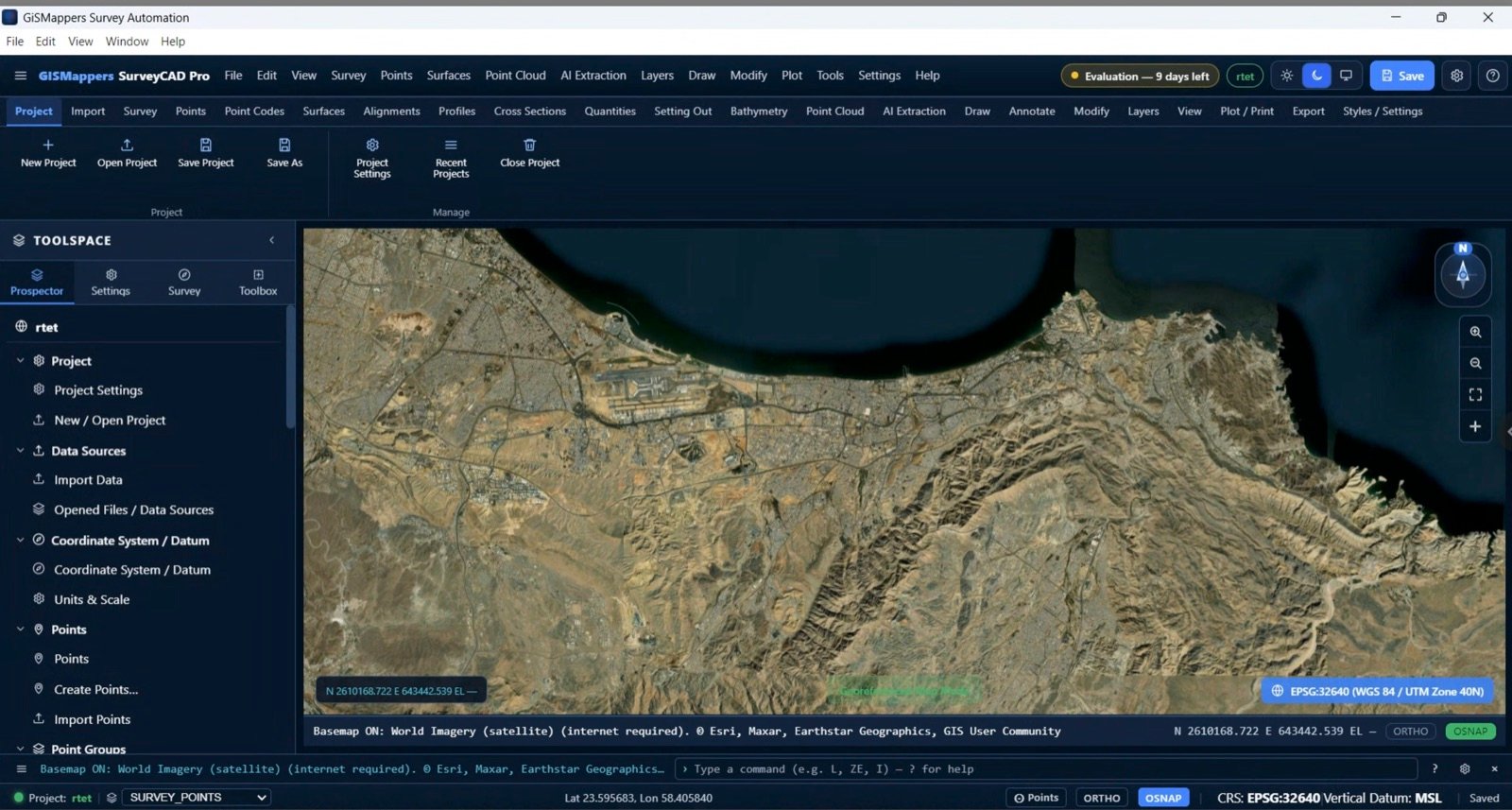
SurveyCAD Pro survey-processing application interface
What it does

One platform from field data to final drawing

SurveyCAD Pro is designed to bring survey processing, CAD drafting, surface modelling and deliverable production into a single, structured workflow — so teams can move from raw points to issued drawings with fewer manual steps.

Import survey points

Bring in field data from CSV, TXT and PENZD point files.

Point code styles & symbols

Apply code libraries, symbols and labels automatically.

Draft topographic drawings

Build linework, boundaries and detail in a CAD environment.

Build TIN / DTM surfaces

Create triangulated terrain models from survey points.

Generate contours

Major and minor contours with labelling and spot levels.

Raster / DEM / ASC / GeoTIFF

Import elevation rasters and georeferenced background data.

Point-cloud-style datasets

Handle large terrain datasets with level-of-detail display.

Alignments & profiles

Road, rail and utility alignments with longitudinal profiles.

Cross sections & quantities

Section generation and cut/fill volume calculation.

Export deliverables

PDF, DXF, CSV, GeoJSON and structured reports.

Built-in QA checks

Validate levels, duplicates and linework before issue.

Layouts & title blocks

A0–A4 sheet layouts with scale and text control.

Inside the platform

SurveyCAD Pro Engines

SurveyCAD Pro is organised into focused engines. Each engine handles one stage of the survey workflow and is designed to pass clean data to the next.

A

Project & Datum Engine

Set standards before any data is imported

  • New project setup with saved templates
  • Units, drawing scale and default text size
  • Coordinate reference system selection
  • Horizontal datum and vertical datum control
  • Default metre unit selection
  • Project standards applied across the drawing
B

Survey Point Engine

Import, organise and validate field data

  • Import PENZD, CSV and TXT point files
  • Point number, easting, northing, elevation, description
  • Configurable point code library
  • Automatic symbol and label assignment
  • Duplicate point and missing elevation checks
  • Topographic, road, utility and bathymetry style libraries
C

CAD Drafting Engine

Familiar drafting tools for survey teams

  • Line, polyline, polygon, circle and text
  • Trim, extend, offset and fillet
  • Break at one point and break between two points
  • Join lines and match properties
  • Layer manager, line styles and CAD symbols
  • Command-panel style input for fast drafting
D

Surface & Contour Engine

Turn points into terrain models

  • Build TIN / DTM from survey points
  • Build surface from point cloud, ASC or DEM data
  • Add boundary and breaklines
  • Create major and minor contours with labels
  • Display slope and spot levels
  • Surface quality checks for gaps and spikes
E

Raster / DEM / Point Cloud Engine

Large elevation datasets, handled smoothly

  • Import GeoTIFF and ESRI ASC files
  • Import DEM and raster elevation data
  • Import progress bar with live percentage
  • Import modal stays visible until loading completes
  • Level-of-detail display for very large point clouds
  • Dots shown first, labels revealed when zoomed in
F

Alignment & Profile Engine

Design centrelines and ground profiles

  • Create alignment from a line or polyline
  • Add chainage / stationing
  • Build horizontal alignments
  • Generate setting-out coordinates
  • Create longitudinal ground profile from a surface
  • Add vertical alignment with crest and sag curves
G

Cross Section & Quantity Engine

Compare surfaces and measure volumes

  • Generate cross sections along an alignment
  • Compare existing ground and design surface
  • Calculate cut and fill volumes
  • Export quantity reports
  • Create section drawings
  • Suited to road, rail, pipeline and platform work
H

Deliverable & Print Engine

Prepare client-ready output

  • Drawing layouts and sheet management
  • A0, A1, A2, A3 and A4 sheet sizes
  • Title block area with scale and text control
  • Export PDF and DXF
  • Export CSV reports and GeoJSON
  • Assemble a final project package
I

Automation & QA Engine

Quality checks before submission

  • Check for missing levels
  • Check for duplicate points
  • Check for open polylines
  • Check for unconnected linework
  • Check for items on the wrong layers
  • Check surface gaps and create a QA report
End to end

Field to Final Drawing Workflow

A clear, repeatable path that helps teams keep projects consistent from the first point to the issued deliverable.

Create project

Start a new project from a standard template.

Choose units, datum, CRS, scale and standards

Lock in the framework before data is imported.

Import points, CAD, raster, DEM, ASC, GeoTIFF or point cloud

Bring all source data into one environment.

Apply point code style library

Symbols and labels assigned automatically.

Draft CAD linework

Build detail, boundaries and feature lines.

Build surface and contours

Generate the terrain model and contour set.

Create alignment and profile

Define centrelines and extract ground profiles.

Generate cross sections and quantities

Compare surfaces and calculate cut and fill.

Prepare layout sheets

Arrange drawings on A0–A4 sheets with title blocks.

Export PDF, DXF, CSV, GeoJSON and reports

Issue a complete, client-ready project package.

Who it is for

Built for Survey and Engineering Teams

SurveyCAD Pro is designed around the day-to-day tasks of survey, mapping and engineering teams.

Topographic survey

Detail surveys, surfaces and contour drawings.

Land survey

Boundary, control and plot mapping deliverables.

Utility survey

Underground and surface utility records in CAD/GIS.

Road and railway survey

Alignments, profiles and corridor cross sections.

Bathymetry and hydrographic survey

Seabed surfaces and depth-based deliverables.

Construction setting-out

Setting-out coordinates and as-built control.

Earthwork quantity calculation

Cut and fill volumes for earthworks and platforms.

GIS and CAD deliverable production

Clean DXF, PDF and GeoJSON outputs for clients.

Formats

Input and output formats

SurveyCAD Pro is designed to work with common survey, CAD and GIS formats so it fits into existing project pipelines. Supported formats, limits and export behaviour are confirmed during the demonstration.

Input formats

CSVTXTPENZDDXFGeoTIFFESRI ASCDEMPoint cloud / large terrainBackground image / map reference

Output formats

PDF drawingsDXF CAD filesCSV reportsGeoJSONContour drawingsProfile drawingsCross-section drawingsQuantity reportsProject package

Want to see SurveyCAD Pro on your data?

Request a guided demonstration and we can walk your team through a field-to-finish workflow on a sample project — from point import to issued drawings.